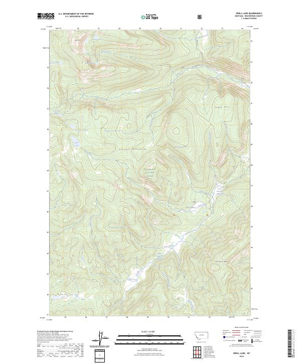
2024 Map of Odell Lake
USGS Topo · Published 2024About this map
The Pioneer Mountains define the character of this high-elevation landscape within the Beaverhead National Forest. This modern survey reveals a dense network of alpine lakes and headwater streams, including the cluster of Bobcat Lakes near Bobcat Mtn and the isolated Schwinegar Lake. The hydrology is complex, with Lacy Creek and Odell Creek carving through the terrain, the latter flowing through the open expanses of Odell Meadows. High-altitude flats such as Table Mtn and Skull Creek Meadows provide distinct geographic landmarks between the steep peaks. The only significant human corridor through this part of the forest is Lacy Creek Rd, which skirts the northern edge of the map. Smaller water bodies like Lake of the Woods and Bear Lake are scattered throughout the quadrangle, illustrating the glacial legacy of the Pioneer Mountains range.
Find a feature on this map
45 named features on this map. Tap any name to fly to it.
Don’t see what you’re looking for? This feature index may not catch every label — zoom into the map to look around manually.
Map Details
Editions of this 2024 Odell Lake Map
This is the sole edition of this map. No revisions or reprints were ever made.
Other maps of this area

1955 · Dillon
USGS Topo · 1:250,000

1957 · Dillon
USGS Topo · 1:250,000

1958 · Dillon
USGS Topo · 1:250,000

1959 · Polaris
USGS Topo · 1:62,500

1962 · Dillon
USGS Topo · 1:250,000

1962 · Stewart Mountain
USGS Topo · 1:24,000

1962 · Proposal Rock
USGS Topo · 1:24,000

1965 · Dillon
USGS Topo · 1:250,000
1978 · Odell Lake
USGS Topo · 1:24,000
1978 · Maurice Mountain
USGS Topo · 1:24,000