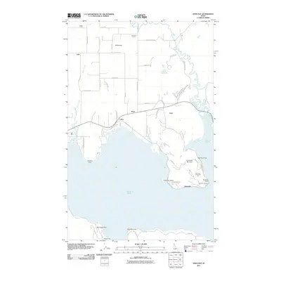
2011 Map of Oden Bay
USGS Topo · Published 2011About this map
Lake Pend Oreille dominates this landscape on the northern shore of the Idaho Panhandle, where the Pack River delta creates a complex network of wetlands and channels known as the Pack River Flats. In the early 21st century, this area shows a transition from the agricultural and rail-dependent roots of Selle and Matchwood to the more residential and recreational focus of Sunnyside and Oden. The Forest Siding railroad point in the northwest reflects the historic timber and transport corridors that shaped the region. On the northern shores, Kootenai Point and Culver mark the developed shoreline, while the higher elevations of Sunnyside Mountain rise to the east. Local history is anchored by the Pack River Cemetery near the river’s winding course and the small settlement of Boyer at a prominent road junction.
Find a feature on this map
56 named features on this map. Tap any name to fly to it.
Don’t see what you’re looking for? This feature index may not catch every label — zoom into the map to look around manually.
Map Details
Editions of this 2011 Oden Bay Map
This is the sole edition of this map. No revisions or reprints were ever made.
Other maps of this area

1901 · Sandpoint
USGS Topo · 1:125,000

1911 · Priest Lake
USGS Topo · 1:250,000

1911 · Sandpoint
USGS Topo · 1:125,000

1913 · Priest Lake
USGS Topo · 1:250,000

1949 · Packsaddle Mtn
USGS Topo · 1:62,500

1951 · Packsaddle Mtn
USGS Topo · 1:62,500

1951 · Elmira
USGS Topo · 1:62,500

1958 · Sandpoint
USGS Topo · 1:250,000

1963 · Sandpoint
USGS Topo · 1:250,000
1968 · Colburn
USGS Topo · 1:24,000