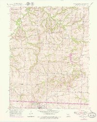
1949 Map of Odessa North
USGS Topo · Published 1979About this map
Little Sni-A-Bar Creek and its many tributaries, including Owl Creek and the East Fork Sni-A-Bar Creek, wind through this rural landscape of Lafayette County. The map reveals a dense network of country schools that served the dispersed farming community during the mid-20th century, such as Flournoy Sch, Hughes Sch, and the uniquely named Cabbage Neck Sch. The southern edge of the survey captures the northern outskirts of Odessa, where the Odessa Cem and the waters of Lake Venita are located near the corridor of the Ohio And Mobile railroad line.
Find a feature on this map
22 named features on this map. Tap any name to fly to it.
Don’t see what you’re looking for? This feature index may not catch every label — zoom into the map to look around manually.
Map Details
Editions of this 1949 Odessa North Map
2 editions found

Other maps of this area

1885 · Warrensburg
USGS Topo · 1:125,000

1887 · Harrisonville
USGS Topo · 1:125,000

1887 · Warrensburg
USGS Topo · 1:125,000

1889 · Lexington
USGS Topo · 1:125,000

1892 · Harrisonville
USGS Topo · 1:125,000

1894 · Harrisonville
USGS Topo · 1:125,000

1894 · Independence
USGS Topo · 1:125,000

1894 · Warrensburg
USGS Topo · 1:125,000

1947 · Jefferson City
USGS Topo · 1:250,000

1947 · Lawrence
USGS Topo · 1:250,000