
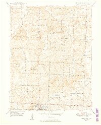
1950 Map of Odessa North
USGS Topo · Published 1950About this map
Odessa serves as the primary hub at the southern edge of this mid-century landscape, where the Gulf Mobile and Ohio railroad corridor provides a vital transportation spine through Lafayette County. The rural character of the region is defined by a dense network of country school districts and small social centers, such as the Greenton Ch and Greenton Cem cluster. The topography is intricately carved by the Little Sni-A-Bar Creek and its various forks, creating a landscape of ridges and hollows that historically dictated the placement of homesteads and winding local roads.
Find a feature on this map
25 named features on this map. Tap any name to fly to it.
Don’t see what you’re looking for? This feature index may not catch every label — zoom into the map to look around manually.
Map Details
Editions of this 1950 Odessa North Map
2 editions found
Other maps of this area

1885 · Warrensburg
USGS Topo · 1:125,000

1887 · Harrisonville
USGS Topo · 1:125,000

1887 · Warrensburg
USGS Topo · 1:125,000

1889 · Lexington
USGS Topo · 1:125,000

1892 · Harrisonville
USGS Topo · 1:125,000

1894 · Harrisonville
USGS Topo · 1:125,000

1894 · Independence
USGS Topo · 1:125,000

1894 · Warrensburg
USGS Topo · 1:125,000

1947 · Jefferson City
USGS Topo · 1:250,000

1947 · Lawrence
USGS Topo · 1:250,000