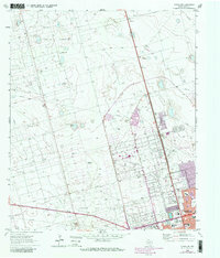
1964 Map of Odessa NW
USGS Topo · Published 1981About this map
The expansive North Cowden Oil Field and adjacent Johnson Oil Field dominate the landscape northwest of Odessa, illustrating the mid-century petroleum economy of Ector County. This survey reveals a terrain defined by industrial infrastructure, with numerous wells such as North Johnson Well and Mexican Well connected by a vast network of pipelines and service roads. Toward the city, the 1964 topography transitions into the residential and civic expansion of the early 1960s, notably around Greenfield Acres. Public life is anchored by institutions like Goliad Sch, Hood Jr High Sch, and the local Coliseum, alongside recreation sites like the Drive-in Theater and Sherwood Park. The map also captures the Odessa-Schlemeyer Field and various extractive sites, including several Gravel Pits and Borrow Pits, which fueled the rapid post-war development of the Permian Basin.
Find a feature on this map
33 named features on this map. Tap any name to fly to it.
Don’t see what you’re looking for? This feature index may not catch every label — zoom into the map to look around manually.
Map Details
Editions of this 1964 Odessa NW Map
4 editions found
Other maps of this area

1954 · Hobbs
USGS Topo · 1:250,000

1954 · Pecos
USGS Topo · 1:250,000

1957 · Pecos
USGS Topo · 1:250,000

1958 · Hobbs
USGS Topo · 1:250,000

1964 · Odessa NE
USGS Topo · 1:24,000

1964 · Odessa SW
USGS Topo · 1:24,000

1964 · Odessa NW
USGS Topo · 1:24,000

1964 · Odessa SE
USGS Topo · 1:24,000

1964 · Douro
USGS Topo · 1:24,000

1965 · Goldsmith
USGS Topo · 1:24,000