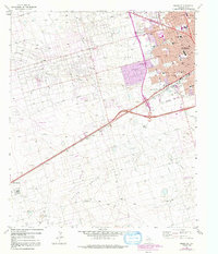
1964 Map of Odessa SW
USGS Topo · Published 1992About this map
The southwest corner of Odessa reveals a landscape transitioning from a bustling urban core to a productive industrial frontier during the mid-1960s. The northern and eastern sections show dense residential development and civic institutions like Odessa College and San Jacinto Sch, while the southern reaches are dominated by the petroleum economy of the Foster Oil Field and the South Cowden Oil Field. Significant infrastructure, including the Texas and Pacific railroad and numerous pipelines, illustrates the logistical backbone required to support the region's energy output.
Find a feature on this map
47 named features on this map. Tap any name to fly to it.
Don’t see what you’re looking for? This feature index may not catch every label — zoom into the map to look around manually.
Map Details
Editions of this 1964 Odessa SW Map
4 editions found
Other maps of this area

1954 · Pecos
USGS Topo · 1:250,000

1957 · Pecos
USGS Topo · 1:250,000

1964 · Odessa NE
USGS Topo · 1:24,000

1964 · Odessa SW
USGS Topo · 1:24,000

1964 · Odessa NW
USGS Topo · 1:24,000

1964 · Odessa SE
USGS Topo · 1:24,000

1964 · Douro
USGS Topo · 1:24,000

1964 · Penwell
USGS Topo · 1:24,000

1964 · Clark Brothers Ranch
USGS Topo · 1:24,000

1965 · South Cowden Ranch
USGS Topo · 1:24,000