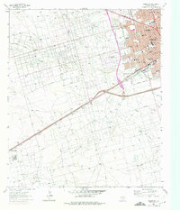
1964 Map of Odessa SW
USGS Topo · Published 1975About this map
Odessa expands westward into the Permian Basin in this mid-1960s survey, showing a landscape defined by the intersection of urban growth and industrial extraction. The city's grid reaches toward Henderson Heights, while the surrounding plains are densely marked by the infrastructure of the Foster Oil Field and the South Cowden Oil Field. This era of development is anchored by a robust network of schools and churches, including Bowie Jr High Sch and Holy Redeemer Ch, reflecting the community's mid-century stabilization.
Find a feature on this map
40 named features on this map. Tap any name to fly to it.
Don’t see what you’re looking for? This feature index may not catch every label — zoom into the map to look around manually.
Map Details
Editions of this 1964 Odessa SW Map
4 editions found
Other maps of this area

1954 · Pecos
USGS Topo · 1:250,000

1957 · Pecos
USGS Topo · 1:250,000

1964 · Odessa NE
USGS Topo · 1:24,000

1964 · Odessa SW
USGS Topo · 1:24,000

1964 · Odessa NW
USGS Topo · 1:24,000

1964 · Odessa SE
USGS Topo · 1:24,000

1964 · Douro
USGS Topo · 1:24,000

1964 · Penwell
USGS Topo · 1:24,000

1964 · Clark Brothers Ranch
USGS Topo · 1:24,000

1965 · South Cowden Ranch
USGS Topo · 1:24,000