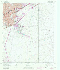
1964 Map of Odessa SE
USGS Topo · Published 1981About this map
Industrial and educational expansion define the southeast corner of Odessa during the mid-1960s, a period marked by significant urban growth and the development of the Permian Basin's energy infrastructure. The map documents an extensive network of schools serving the community, including Ector H S, Blackshear Sch, and Bonham Jr H S, reflecting the mid-century population boom. Economic activity is anchored by a sprawling Refinery and Chemical Plant near the intersection of the Texas and Pacific and Missouri railroads, while the terrain outside the city limits is shaped by the Headlee and Dora Roberts Oil Field. Natural features like the Monahans Draw cut through the landscape, punctuated by local landmarks such as Walters Ranch and several Gravel Pits, illustrating the transition from open ranching country to a concentrated industrial hub.
Find a feature on this map
43 named features on this map. Tap any name to fly to it.
Don’t see what you’re looking for? This feature index may not catch every label — zoom into the map to look around manually.
Map Details
Editions of this 1964 Odessa SE Map
3 editions found
Other maps of this area

1954 · Pecos
USGS Topo · 1:250,000

1957 · Pecos
USGS Topo · 1:250,000

1964 · Odessa NE
USGS Topo · 1:24,000

1964 · Odessa SW
USGS Topo · 1:24,000

1964 · Odessa NW
USGS Topo · 1:24,000

1964 · Odessa SE
USGS Topo · 1:24,000

1964 · Parks
USGS Topo · 1:24,000

1964 · Clark Brothers Ranch
USGS Topo · 1:24,000

1965 · Southwest Midland
USGS Topo · 1:24,000

1965 · South Cowden Ranch
USGS Topo · 1:24,000