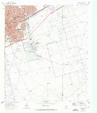
1964 Map of Odessa SE
USGS Topo · Published 1975About this map
The industrial and residential expansion of Odessa is evident in this mid-century survey, where the grid of the city meets the extensive fossil fuel infrastructure of the Permian Basin. The northern portion of the map is dense with civic institutions, including Dowling Sch, Blackshear Sch, and the Cemetery, illustrating the community's growth along the Texas and Pacific railroad. A distinctive feature of this landscape is the massive concentration of energy infrastructure, from the large Refinery and Sewage Disposal plant to the sprawling networks of the Headlee Oil Field and Dora Roberts Field.
Find a feature on this map
31 named features on this map. Tap any name to fly to it.
Don’t see what you’re looking for? This feature index may not catch every label — zoom into the map to look around manually.
Map Details
Editions of this 1964 Odessa SE Map
3 editions found
Other maps of this area

1954 · Pecos
USGS Topo · 1:250,000

1957 · Pecos
USGS Topo · 1:250,000

1964 · Odessa NE
USGS Topo · 1:24,000

1964 · Odessa SW
USGS Topo · 1:24,000

1964 · Odessa NW
USGS Topo · 1:24,000

1964 · Odessa SE
USGS Topo · 1:24,000

1964 · Parks
USGS Topo · 1:24,000

1964 · Clark Brothers Ranch
USGS Topo · 1:24,000

1965 · Southwest Midland
USGS Topo · 1:24,000

1965 · South Cowden Ranch
USGS Topo · 1:24,000