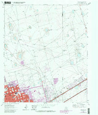
1964 Map of Odessa NE
USGS Topo · Published 1981About this map
The expansion of Odessa during the mid-1960s is clearly visible in this survey, showing a growing urban grid pushing northeast into the Permian Basin oil fields. The transition from industrial landscape to residential development is marked by the presence of Sunset Memorial Gardens (Cem) and several community institutions, including Permian High Sch and Chapel Hill Ch. An intricate network of pipelines and aqueducts crisscrosses the landscape, supporting the extensive drilling operations at Headlee Field, Ratliff Field, and Hallanan Field. Beyond the encroaching city limits, the land remains dominated by ranching and energy production, anchored by the Ratliff Ranch. The Missouri Pacific railroad serves as the primary transportation artery, running parallel to early shopping centers like the Sherwood Shopping Center. This edition includes revisions from the late 1970s, providing a layered view of the region's rapid development.
Find a feature on this map
33 named features on this map. Tap any name to fly to it.
Don’t see what you’re looking for? This feature index may not catch every label — zoom into the map to look around manually.
Map Details
Editions of this 1964 Odessa NE Map
4 editions found
Other maps of this area

1954 · Hobbs
USGS Topo · 1:250,000

1954 · Pecos
USGS Topo · 1:250,000

1957 · Pecos
USGS Topo · 1:250,000

1958 · Hobbs
USGS Topo · 1:250,000

1964 · Odessa NE
USGS Topo · 1:24,000

1964 · Odessa SW
USGS Topo · 1:24,000

1964 · Odessa NW
USGS Topo · 1:24,000

1964 · Odessa SE
USGS Topo · 1:24,000

1964 · Parks
USGS Topo · 1:24,000

1965 · Southwest Midland
USGS Topo · 1:24,000