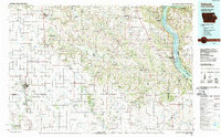
1984 Map of Oelwein
USGS Topo · Published 1989About this map
The Mississippi River and Wisconsin River confluence dominates the eastern boundary of this mid-1980s landscape, where steep bluffs give way to the rolling agricultural plateaus of northeast Iowa. This region is marked by significant cultural and natural preserves, including the prehistoric earthworks at Effigy Mounds National Monument and the high overlooks of Pikes Peak State Park. Moving inland, the Turkey River and Volga River carve intricate drainage patterns through townships like Volga and Jefferson.
Find a feature on this map
177 named features on this map. Tap any name to fly to it.
Don’t see what you’re looking for? This feature index may not catch every label — zoom into the map to look around manually.
Map Details
Editions of this 1984 Oelwein Map
2 editions found
Other maps of this area

1900 · Anamosa
USGS Topo · 1:125,000

1900 · Lancaster
USGS Topo · 1:125,000

1901 · Peosta
USGS Topo · 1:125,000

1901 · Oelwein
USGS Topo · 1:125,000

1902 · Elkader
USGS Topo · 1:125,000

1903 · Waukon
USGS Topo · 1:125,000

1903 · Winthrop
USGS Topo · 1:125,000

1904 · Lancaster
USGS Topo · 1:125,000

1906 · Decorah
USGS Topo · 1:125,000

1908 · Lancaster
USGS Topo · 1:125,000