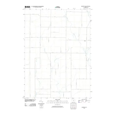
2010 Map of Oelwein SE
USGS Topo · Published 2010About this map
Spangler Cemetery stands as a solitary historic landmark in this corner of Buchanan County, situated near the headwaters of the regional drainage network. The landscape is defined by the complex branching of local waterways, including Buffalo Creek and its tributaries, the West Branch Buffalo Creek and East Branch Buffalo Creek. This network of streams organizes the surrounding rural landscape, which is partitioned by a strict grid of county roads such as Lawrence Ave and Nathen Bethel Ave. The drainage pattern suggests a terrain of low rises and subtle valleys where the West Branch Pine Creek and East Branch Pine Creek converge into the main stem of Pine Creek. This 2010 survey reflects a stable agricultural layout, preserving the same family-named road designations and small-scale watercourse names that have guided local navigation and property boundaries for generations.
Find a feature on this map
37 named features on this map. Tap any name to fly to it.
Don’t see what you’re looking for? This feature index may not catch every label — zoom into the map to look around manually.
Map Details
Editions of this 2010 Oelwein SE Map
This is the sole edition of this map. No revisions or reprints were ever made.
Other maps of this area

1901 · Oelwein
USGS Topo · 1:125,000

1903 · Winthrop
USGS Topo · 1:125,000

1959 · Dubuque
USGS Topo · 1:250,000

1961 · Dubuque
USGS Topo · 1:250,000

1962 · Dubuque
USGS Topo · 1:250,000

1965 · Arlington
USGS Topo · 1:24,000

1965 · Lamont
USGS Topo · 1:24,000
1973 · Independence
USGS Topo · 1:24,000
1973 · Quasqueton
USGS Topo · 1:24,000
1973 · Winthrop
USGS Topo · 1:24,000