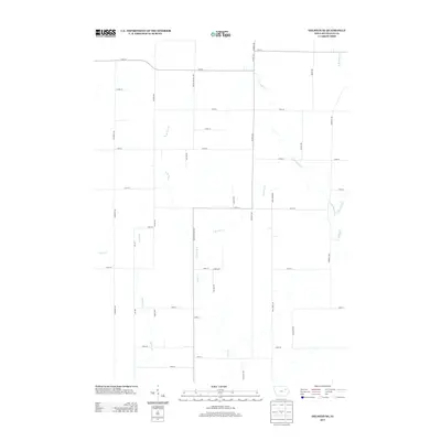
2013 Map of Oelwein SE
USGS Topo · Published 2013About this map
Agricultural patterns and a network of named waterways characterize this portion of Buchanan County. The landscape is defined by the branching tributaries of Buffalo Cr and Pine Cr, which move across the section line grid in a complex drainage system. Notable water features include Harter Cr and the winding course of Malone Cr to the southwest. The human imprint is seen in the strict orthographic road system, anchored by corridors like Co Hwy-C57 and numerous family-named avenues such as Nathan Bethel Ave and O'Brien Ave. This layout reflects the enduring township-and-range survey system, where farmsteads are connected by numbered streets and named avenues that facilitate the region's rural economy. The presence of W Br Buffalo Cr and E Br Buffalo Cr in the northeast quadrant highlights the importance of natural drainage to the local terrain.
Find a feature on this map
41 named features on this map. Tap any name to fly to it.
Don’t see what you’re looking for? This feature index may not catch every label — zoom into the map to look around manually.
Map Details
Editions of this 2013 Oelwein SE Map
This is the sole edition of this map. No revisions or reprints were ever made.
Other maps of this area

1901 · Oelwein
USGS Topo · 1:125,000

1903 · Winthrop
USGS Topo · 1:125,000

1959 · Dubuque
USGS Topo · 1:250,000

1961 · Dubuque
USGS Topo · 1:250,000

1962 · Dubuque
USGS Topo · 1:250,000

1965 · Arlington
USGS Topo · 1:24,000

1965 · Lamont
USGS Topo · 1:24,000
1973 · Independence
USGS Topo · 1:24,000
1973 · Quasqueton
USGS Topo · 1:24,000
1973 · Winthrop
USGS Topo · 1:24,000