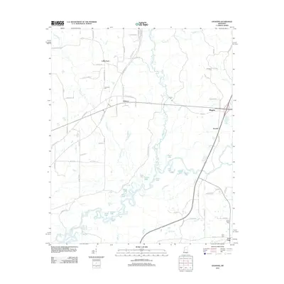
2012 Map of Ofahoma
USGS Topo · Published 2012About this map
The Yockanookany River winds through central Leake County, Mississippi, feeding a complex system of oxbows and wetlands including Elbow Lake, Long Lake, and Black Lake. This riverine environment defines the central corridor of the landscape, while the southern boundary is marked by the course of the Pearl River. Settlement is scattered across higher ground, with the community of Ofahoma situated near the intersection of Old Robinson Rd and the Natchez Trace Pkwy, reflecting the area's deep connection to early transit routes. For genealogists, the map identifies several rural burial sites such as Greenwood Cem, Tribulation Cem, and Rising Chapel Cem. The layout of the road network, including family-named routes like Dan Boone Rd and Emzy Smith Rd, suggests a landscape shaped by generations of local agricultural life and small communities like Forest Grove and Good Hope.
Find a feature on this map
80 named features on this map. Tap any name to fly to it.
Don’t see what you’re looking for? This feature index may not catch every label — zoom into the map to look around manually.
Map Details
Editions of this 2012 Ofahoma Map
This is the sole edition of this map. No revisions or reprints were ever made.
Other maps of this area

1953 · Meridian
USGS Topo · 1:250,000

1957 · Meridian
USGS Topo · 1:250,000

1960 · Sharon
USGS Topo · 1:62,500

1961 · Carthage
USGS Topo · 1:62,500

1962 · Thomastown
USGS Topo · 1:62,500

1964 · Camden
USGS Topo · 1:24,000

1965 · Meridian
USGS Topo · 1:250,000
1966 · Goodman
USGS Topo · 1:62,500

1984 · Carthage
USGS Topo · 1:100,000
1988 · Thomastown
USGS Topo · 1:24,000