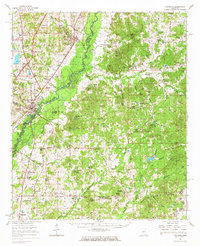
1966 Map of Goodman
USGS Topo · Published 1967About this map
Goodman serves as a central hub in this mid-1960s Mississippi landscape, situated where the Illinois Central Railroad skirts the edge of the Big Black River basin. This survey documents a transition from the river bottomlands to the higher ground of Center Ridge and Sandy Ridge. The map captures the significant educational presence of the Holmes County Junior College and the Velma Jackson High Sch, alongside numerous rural congregations such as Mary Magdalene Ch and True Light Ch.
Find a feature on this map
99 named features on this map. Tap any name to fly to it.
Don’t see what you’re looking for? This feature index may not catch every label — zoom into the map to look around manually.
Map Details
Editions of this 1966 Goodman Map
This is the sole edition of this map. No revisions or reprints were ever made.
Other maps of this area

1940 · Lexington
USGS Topo · 1:62,500

1953 · Meridian
USGS Topo · 1:250,000

1953 · Greenwood
USGS Topo · 1:250,000

1953 · West Point
USGS Topo · 1:250,000

1955 · Jackson
USGS Topo · 1:250,000

1956 · Greenwood
USGS Topo · 1:250,000

1957 · Meridian
USGS Topo · 1:250,000

1957 · Lexington
USGS Topo · 1:62,500

1958 · West Point
USGS Topo · 1:250,000

1958 · Lexington
USGS Topo · 1:62,500