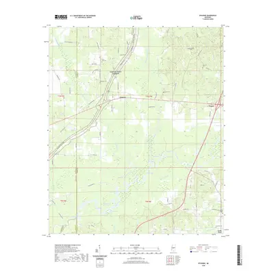
2020 Map of Ofahoma
USGS Topo · Published 2020About this map
Pellaphalia Creek and the Yockanookany River define the intricate hydrology of this central Mississippi landscape where Leake, Madison, and Scott counties meet. The historic path of the Natchez Trace Parkway cuts across the northern terrain, passing the small settlement of Ofahoma and several ancestral burial grounds including Greenwood Cem and Forest Grove Cem. To the south, the river bottomlands give way to a dense network of oxbow lakes and sloughs, such as Alligator Lake, Gogg Lake, and Gravel Slough.
Find a feature on this map
83 named features on this map. Tap any name to fly to it.
Don’t see what you’re looking for? This feature index may not catch every label — zoom into the map to look around manually.
Map Details
Editions of this 2020 Ofahoma Map
This is the sole edition of this map. No revisions or reprints were ever made.
Other maps of this area

1953 · Meridian
USGS Topo · 1:250,000

1957 · Meridian
USGS Topo · 1:250,000

1960 · Sharon
USGS Topo · 1:62,500

1961 · Carthage
USGS Topo · 1:62,500

1962 · Thomastown
USGS Topo · 1:62,500

1964 · Camden
USGS Topo · 1:24,000

1965 · Meridian
USGS Topo · 1:250,000
1966 · Goodman
USGS Topo · 1:62,500

1984 · Carthage
USGS Topo · 1:100,000
1988 · Thomastown
USGS Topo · 1:24,000