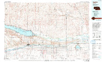
1985 Map of Ogallala
USGS Topo · Published 1994About this map
The vast waters of Lake McConaughy and its adjacent Lake Ogallala State Recreation Area dominate this mid-1980s landscape, serving as a massive hydraulic hub for the region. The map reveals an intricate network of irrigation and power canals, including the Sutherland Canal and the Keith Lincoln Canal, which divert water from the North Platte River to support agriculture across the High Plains. Parallel to the South Platte River, the Union Pacific railroad and Interstate 80 corridor form the backbone of the local economy, connecting grain-handling settlements like Ogallala, Paxton, and Sutherland. Beyond the river valleys, the terrain shifts into the distinctive north-south drainage patterns of the Sandhills, marked by labels such as Spotted Horse Valley and Wildhorse Valley. This survey captures the intensive water management systems required to sustain the towns and farms between the two river forks.
Find a feature on this map
61 named features on this map. Tap any name to fly to it.
Don’t see what you’re looking for? This feature index may not catch every label — zoom into the map to look around manually.
Map Details
Editions of this 1985 Ogallala Map
2 editions found
Other maps of this area

1897 · Ogallala
USGS Topo · 1:125,000

1898 · Paxton
USGS Topo · 1:125,000

1899 · North Platte
USGS Topo · 1:125,000

1900 · Chappell
USGS Topo · 1:125,000

1900 · Ogallala
USGS Topo · 1:125,000

1901 · Paxton
USGS Topo · 1:125,000

1902 · North Platte
USGS Topo · 1:125,000

1949 · Arthur
USGS Topo · 1:62,500

1949 · Flats
USGS Topo · 1:62,500

1949 · Rackett
USGS Topo · 1:62,500