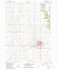
1982 Map of Ogden
USGS Topo · Published 1983About this map
The agricultural heart of Boone County is centered on Ogden, appearing here as a growing hub defined by the intersection of rural life and early industrial infrastructure. The town's grid is anchored by St Johns church and several educational facilities, including Howe Sch and North Sch. To the north, the landscape is shaped by the sprawling Don Williams County Park and the waters of Don Williams Lake, providing a contrast to the surrounding section lines and farmsteads.
Find a feature on this map
29 named features on this map. Tap any name to fly to it.
Don’t see what you’re looking for? This feature index may not catch every label — zoom into the map to look around manually.
Map Details
Editions of this 1982 Ogden Map
This is the sole edition of this map. No revisions or reprints were ever made.
Other maps of this area

1911 · Madrid
USGS Topo · 1:62,500

1914 · Madrid
USGS Topo · 1:62,500

1916 · Boone
USGS Topo · 1:62,500

1950 · Perry
USGS Topo · 1:62,500

1951 · Perry
USGS Topo · 1:62,500

1951 · Ogden
USGS Topo · 1:62,500

1954 · Omaha
USGS Topo · 1:250,000

1954 · Waterloo
USGS Topo · 1:250,000

1954 · Fort Dodge
USGS Topo · 1:250,000

1954 · Des Moines
USGS Topo · 1:250,000