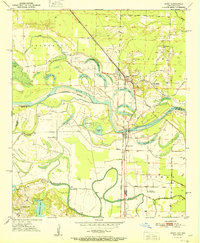
1951 Map of Ogden
USGS Topo · Published 1951About this map
Red River oxbows and marshy bottomlands dominate the borderlands between Arkansas and Texas in this early 1950s survey. The town of Ogden sits at a strategic junction where the Kansas City Southern railroad tracks cross the river plains, surrounded by a landscape of named cutoff lakes like Mill Lake, First Lake, and Summer Hill Lake. This area reflects a mid-century rural educational and social network, evidenced by the presence of the Rosenwald Sch and Washington Sch, alongside several country churches such as New Zion Ch and Summer Hill Ch. The mapping of these institutions provides a specific record of local community life just before significant school consolidations and demographic shifts. To the south, the Texarkana Radio Range Station and the settlement of Wamba sit near the winding McKinney Bayou, illustrating the technological and agricultural character of the Red River valley in this era.
Find a feature on this map
38 named features on this map. Tap any name to fly to it.
Don’t see what you’re looking for? This feature index may not catch every label — zoom into the map to look around manually.
Map Details
Editions of this 1951 Ogden Map
2 editions found
Other maps of this area

1909 · Texarkana
USGS Topo · 1:62,500

1950 · Ashdown East
USGS Topo · 1:24,000

1950 · Ashdown West
USGS Topo · 1:24,000

1950 · Ogden
USGS Topo · 1:24,000

1950 · Red Bluff
USGS Topo · 1:24,000

1950 · Barkman
USGS Topo · 1:24,000

1951 · Ashdown West
USGS Topo · 1:24,000

1951 · Ogden
USGS Topo · 1:24,000

1951 · Red Bluff
USGS Topo · 1:24,000

1951 · Ashdown East
USGS Topo · 1:24,000