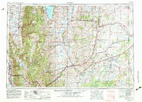
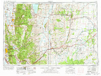
1954 Map of Ogden
USGS Topo · Published 1983About this map
The Wasatch Range and Cache Range anchor this mid-century survey, defining the rugged corridor of settlement that stretches from Kaysville north through Ogden to Logan. The map captures the complex interaction between the high mountain terrain and the vital water systems of the Bear River, Weber River, and the extensive Bear Lake at the Idaho border. To the east, the landscape transitions into the high desert plains of Wyoming, marked by the distinctive Bear River Divide and the Absaroka Ridge. This transition highlights the strategic importance of early western corridors, evidenced by the Union Pacific Railroad and the Fort Bridger State Historic Site, which sit alongside newer developments like the Defense Depot Ogden. The region's conservation and recreation history is further grounded by the vast stretches of the Cache National Forest and the fossil-rich grounds of Fossil Butte National Monument.
Find a feature on this map
173 named features on this map. Tap any name to fly to it.
Don’t see what you’re looking for? This feature index may not catch every label — zoom into the map to look around manually.
Map Details
Editions of this 1954 Ogden Map
3 editions found

Other maps of this area

1885 · Salt Lake
USGS Topo · 1:250,000

1885 · Ashley
USGS Topo · 1:250,000

1885 · Uinta
USGS Topo · 1:250,000

1885 · Tooele Valley
USGS Topo · 1:250,000

1900 · Coalville
USGS Topo · 1:125,000
1901 · Hayden Peak
USGS Topo · 1:125,000
1903 · Hayden Peak
USGS Topo · 1:125,000

1903 · Coalville
USGS Topo · 1:125,000

1905 · Gilbert Peak
USGS Topo · 1:125,000

1906 · Gilbert Peak
USGS Topo · 1:125,000