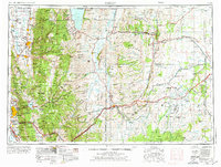
1954 Map of Ogden
USGS Topo · Published 1975About this map
Ogden and the base of the Wasatch Mountains serve as the western gateway to a complex landscape of ridges and high plateaus in this mid-century survey. The urban corridor of North Ogden, South Ogden, and Washington Terrace contrasts with the industrial footprint of the Ogden Arsenal and the State Hospital. Beyond the peaks of the Wasatch Range, the geography opens into the Cache National Forest and the fertile Cache Valley, where settlements like Logan, Hyrum, and Richmond follow the Little Bear River.
Find a feature on this map
270 named features on this map. Tap any name to fly to it.
Don’t see what you’re looking for? This feature index may not catch every label — zoom into the map to look around manually.
Map Details
Editions of this 1954 Ogden Map
3 editions found

Other maps of this area

1885 · Salt Lake
USGS Topo · 1:250,000

1885 · Ashley
USGS Topo · 1:250,000

1885 · Uinta
USGS Topo · 1:250,000

1885 · Tooele Valley
USGS Topo · 1:250,000

1900 · Coalville
USGS Topo · 1:125,000

1901 · Hayden Peak
USGS Topo · 1:125,000

1903 · Hayden Peak
USGS Topo · 1:125,000

1903 · Coalville
USGS Topo · 1:125,000

1905 · Gilbert Peak
USGS Topo · 1:125,000

1906 · Gilbert Peak
USGS Topo · 1:125,000