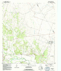
1994 Map of Oglesby
USGS Topo · Published 1995About this map
Oglesby serves as the primary hub in this Coryell County landscape, situated where the Old Railroad Grade meets a network of local roads and creek systems. To the southeast, the Naval Weapons Industrial Reserve Plant occupies a significant portion of the territory, while the Leon River winds along the southern boundary, flanked by an extensive Levee. The map documents a rural transition where former industry is noted at Lime City (Site), suggesting a shift from previous industrial or quarrying activity to more modern infrastructure including a sewage disposal facility and radio towers.
Find a feature on this map
30 named features on this map. Tap any name to fly to it.
Don’t see what you’re looking for? This feature index may not catch every label — zoom into the map to look around manually.
Map Details
Editions of this 1994 Oglesby Map
This is the sole edition of this map. No revisions or reprints were ever made.
Other maps of this area

1888 · Meridian
USGS Topo · 1:125,000

1892 · Temple
USGS Topo · 1:125,000

1892 · Waco
USGS Topo · 1:125,000

1894 · Meridian
USGS Topo · 1:125,000

1894 · Gatesville
USGS Topo · 1:125,000

1920 · Waco
USGS Topo · 1:125,000

1924 · Temple 2-C
USGS Topo · 1:48,000

1931 · Valley Mills
USGS Topo · 1:62,500

1931 · Mc Gregor
USGS Topo · 1:62,500

1947 · Oglesby
USGS Topo · 1:24,000