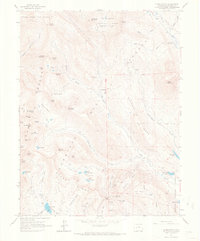
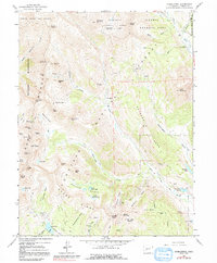
1961 Map of Oh-Be-Joyful
USGS Topo · Published 1968About this map
Ruby Range and the high alpine basins of the White River National Forest dominate this 1961 survey, where the mining heritage of Gunnison County is clearly etched into the terrain. The settlements of Pittsburg and Elkton appear as focal points for historical industrial activity, surrounded by a high concentration of hard-rock workings such as the Pittsburg Mine, Augusta Mine, and the Painter Boy Mine. The landscape is a network of high-altitude transport, from the pack trail crossing Oh-be-joyful Pass to the old railroad grade following the Slate River. This map captures the region when the economy was transitioning from active mining toward recreation, evidenced by the Gothic Picnic Ground and the preservation of the Gunnison National Forest. Natural features like Lake Irwin, Blue Lake, and the massive Gunnison Scarp provide context for the steep, glaciated geography that challenged early prospectors and engineers.
Find a feature on this map
78 named features on this map. Tap any name to fly to it.
Don’t see what you’re looking for? This feature index may not catch every label — zoom into the map to look around manually.
Map Details
Editions of this 1961 Oh-Be-Joyful Map
5 editions found
Other maps of this area

1888 · Crested Butte
USGS Topo · 1:62,500

1888 · Anthracite
USGS Topo · 1:62,500

1889 · Crested Butte
USGS Topo · 1:62,500

1889 · Anthracite
USGS Topo · 1:62,500

1893 · Anthracite
USGS Topo · 1:62,500

1893 · Crested Butte
USGS Topo · 1:62,500

1893 · Aspen
USGS Topo · 1:62,500

1894 · Anthracite
USGS Topo · 1:62,500

1895 · Aspen
USGS Topo · 1:62,500

1909 · Mount Jackson
USGS Topo · 1:125,000