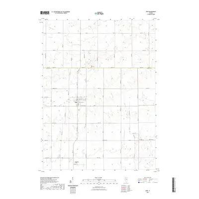
2021 Map of Ohio
USGS Topo · Published 2021About this map
The agricultural landscape of northern Bureau County and southern Lee County is defined by its rectilinear grid and the small rural centers of Ohio and Kasbeer. This 2021 survey illustrates the modern configuration of this farming region, where the Lee Co and Bureau Co line follows Baseline Rd across a terrain drained by Walnut Creek, Lime Creek, and Masters Fork. For local historians and genealogists, several traditional burial grounds are documented, including Saint Marys Cemetery north of the county line and Union Cemetery situated just east of Ohio. The road network remains a primary feature of the landscape, with family-named routes such as Rogers Rd, Sheehan Rd, and Hannon Rd providing access to the sectioned fields that have supported Illinois agriculture for generations.
Find a feature on this map
65 named features on this map. Tap any name to fly to it.
Don’t see what you’re looking for? This feature index may not catch every label — zoom into the map to look around manually.
Map Details
Editions of this 2021 Ohio Map
This is the sole edition of this map. No revisions or reprints were ever made.
Other maps of this area

1893 · Hennepin
USGS Topo · 1:62,500

1909 · Hennepin
USGS Topo · 1:62,500

1911 · Hennepin
USGS Topo · 1:62,500

1921 · Buda
USGS Topo · 1:62,500

1923 · Buda
USGS Topo · 1:62,500

1949 · Walnut
USGS Topo · 1:62,500

1951 · Amboy
USGS Topo · 1:62,500

1958 · Aurora
USGS Topo · 1:250,000

1961 · Aurora
USGS Topo · 1:250,000
1966 · Malden
USGS Topo · 1:24,000