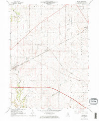
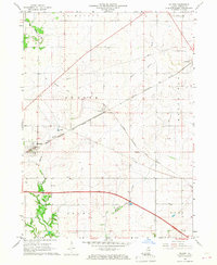
1966 Map of Malden
USGS Topo · Published 1967About this map
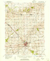
The Chicago Burlington and Quincy railroad corridor serves as the primary artery for Bureau County in the mid-1960s, threading through the established villages of Malden and Arlington. This area, situated at the intersection of several townships including Berlin and Westfield, is defined by a dense grid of farm roads and significant rail infrastructure, including the Chicago and North Western line and a long section of Old Railroad Grade north of Zearing. The landscape is etched by the meandering courses of Big Bureau Creek and East Bureau Creek, which break the geometric precision of the township sections. Local industry and social history are evident in the scattered Gravel Pits and the presence of Berean Cem, while a prominent Pipeline cuts diagonally across the northern tier of the townships, illustrating the evolving utility infrastructure of the period.
Find a feature on this map
20 named features on this map. Tap any name to fly to it.
Don’t see what you’re looking for? This feature index may not catch every label — zoom into the map to look around manually.
Map Details
Editions of this 1966 Malden Map
2 editions found
Other maps of this area

1893 · Hennepin
USGS Topo · 1:62,500

1893 · Lasalle
USGS Topo · 1:62,500

1909 · Hennepin
USGS Topo · 1:62,500

1911 · La Salle
USGS Topo · 1:62,500

1911 · Hennepin
USGS Topo · 1:62,500

1913 · La Salle
USGS Topo · 1:62,500
1947 · La Salle
USGS Topo · 1:62,500
1951 · Amboy
USGS Topo · 1:62,500
1952 · Mendota
USGS Topo · 1:62,500

1958 · Aurora
USGS Topo · 1:250,000