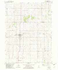
1982 Map of Ohio
USGS Topo · Published 1982About this map
Ohio and its surrounding prairie landscapes are defined by a geometric grid of rural routes and the diagonal path of the Burlington Northern railroad. The village center is characterized by its organized street plan and community infrastructure, including a local Park and Sewage Disposal facility. One of the most significant historical markers on this sheet is the Old Indian Treaty Boundary, which cuts horizontally across the southern township lines, providing a tangible link to the regional 19th-century land cessions and the early American surveying process.
Find a feature on this map
29 named features on this map. Tap any name to fly to it.
Don’t see what you’re looking for? This feature index may not catch every label — zoom into the map to look around manually.
Map Details
Editions of this 1982 Ohio Map
This is the sole edition of this map. No revisions or reprints were ever made.
Other maps of this area

1893 · Hennepin
USGS Topo · 1:62,500

1909 · Hennepin
USGS Topo · 1:62,500

1911 · Hennepin
USGS Topo · 1:62,500

1921 · Buda
USGS Topo · 1:62,500

1923 · Buda
USGS Topo · 1:62,500

1949 · Walnut
USGS Topo · 1:62,500

1951 · Amboy
USGS Topo · 1:62,500

1958 · Aurora
USGS Topo · 1:250,000

1961 · Aurora
USGS Topo · 1:250,000
1966 · Malden
USGS Topo · 1:24,000