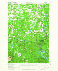
1949 Map of Ohop Valley
USGS Topo · Published 1964About this map
The Nisqually River carves a deep path through this southern Pierce County landscape, serving as a natural boundary between several timber-rich townships. In this post-war period, Eatonville serves as the regional hub, situated at the confluence of the Mashel River and Ohop Creek. The presence of the Chic Mil St P & Pac RR and the Mountain Highway illustrates a mid-century infrastructure reliant on both heavy rail and emerging automotive routes. Education is decentralized across rural districts, evidenced by the Lacamas School, Weyerhaeuser School, and Edgerton School. Further south, the landscape is defined by the industrial and academic footprint of the Pack Demonstration Forest and the La Grande Dam, marking the era's focus on sustainable forestry and hydroelectric development. Smaller hamlets like Clay City and Johnsons Corner dot the northern reaches, while the Fort Lewis Military Reservation occupies the northwest corner.
Find a feature on this map
84 named features on this map. Tap any name to fly to it.
Don’t see what you’re looking for? This feature index may not catch every label — zoom into the map to look around manually.
Map Details
Editions of this 1949 Ohop Valley Map
2 editions found

Other maps of this area

1897 · Tacoma
USGS Topo · 1:125,000

1900 · Tacoma
USGS Topo · 1:125,000

1916 · Chehalis
USGS Topo · 1:125,000

1937 · Eatonville
USGS Topo · 1:125,000

1940 · Anderson Island
USGS Topo · 1:62,500

1941 · Tanwax Lake
USGS Topo · 1:62,500

1941 · Tacoma South
USGS Topo · 1:62,500

1942 · Lake Tapps
USGS Topo · 1:62,500

1943 · Willapa
USGS Topo · 1:62,500

1944 · Lake Tapps
USGS Topo · 1:62,500