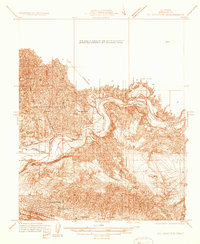
1933 Map of Oil Center
USGS Topo · Published 1933About this map
The Kern River Oil Field dominates this 1930s landscape, illustrating the industrial footprint of petroleum extraction north of Bakersfield. The map captures the specialized infrastructure of the era, from the concentration of workers at the Oil Center (P.O.) to small company-driven settlements like Oil City and Treadwell. The social fabric of these oil communities is revealed through localized institutions such as Petroleum Sch, Aztec Sch, and Toltec Sch.
Find a feature on this map
28 named features on this map. Tap any name to fly to it.
Don’t see what you’re looking for? This feature index may not catch every label — zoom into the map to look around manually.
Map Details
Editions of this 1933 Oil Center Map
This is the sole edition of this map. No revisions or reprints were ever made.
Other maps of this area

1906 · Bakersfield
USGS Topo · 1:62,500

1910 · Buena Vista Lake
USGS Topo · 1:125,000

1912 · Buena Vista Lake
USGS Topo · 1:125,000

1914 · Caliente
USGS Topo · 1:125,000

1929 · Fairfax School
USGS Topo · 1:31,680

1930 · Oildale
USGS Topo · 1:31,680

1931 · Edison
USGS Topo · 1:31,680

1932 · North of Oildale
USGS Topo · 1:31,680

1932 · Fairfax School
USGS Topo · 1:31,680
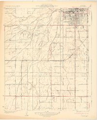
1932 · Gosford
USGS Topo · 1:31,680