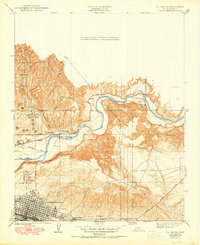
1950 Map of Oil Center
USGS Topo · Published 1950About this map
Bakersfield and its industrial outskirts are defined by the intensive petroleum development and irrigation systems found here in the mid-twentieth century. The landscape is a network of water management and extraction, where the Kern River is tapped by the Beardsley Canal, China Grade Canal, and South Side Canal to support the surrounding valley. To the north, the focus shifts to the oil fields, where specialized settlements like Oil Center and Oil City sit alongside schools such as Aztec Sch and Petroleum Sch. The presence of the Southern Pacific railroad and the County Hospital reflects the essential infrastructure supporting a growing labor force. Steep drainage cuts like Sacramento Gulch and West Shore Gulch provide a stark contrast to the expanding street grid visible along Nile Street, capturing a period of transition as the city limits began to press against the industrial and agricultural machinery of the region.
Find a feature on this map
24 named features on this map. Tap any name to fly to it.
Don’t see what you’re looking for? This feature index may not catch every label — zoom into the map to look around manually.
Map Details
Editions of this 1950 Oil Center Map
This is the sole edition of this map. No revisions or reprints were ever made.
Other maps of this area

1906 · Bakersfield
USGS Topo · 1:62,500

1910 · Buena Vista Lake
USGS Topo · 1:125,000

1912 · Buena Vista Lake
USGS Topo · 1:125,000

1914 · Caliente
USGS Topo · 1:125,000

1929 · Fairfax School
USGS Topo · 1:31,680

1930 · Oildale
USGS Topo · 1:31,680

1931 · Edison
USGS Topo · 1:31,680

1932 · North of Oildale
USGS Topo · 1:31,680

1932 · Fairfax School
USGS Topo · 1:31,680
1932 · Gosford
USGS Topo · 1:31,680