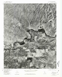
1978 Map of Oil Center
USGS Topo · Published 1981About this map
The Kern River carves a winding path through this central California landscape, revealing the stark transition between the developed streets of Bakersfield and the industrial terrain of the northern oil fields. This orthophotoquad provides an unvarnished aerial perspective of the region in the late 1970s, where the dense grid of residential neighborhoods in the southwest gives way to the open, rugged land surrounding the namesake settlement of Oil Center. The aerial photography highlights the topographical character of the area, specifically the distinct elevations of Round Mtn and Ant Hill that rise above the river valley. For researchers, the map clearly differentiates between the suburban expansion of the city and the specialized land use required for energy production during this era, capturing the footprint of infrastructure as it followed the natural contours of the Kern River basin.
Find a feature on this map
5 named features on this map. Tap any name to fly to it.
Don’t see what you’re looking for? This feature index may not catch every label — zoom into the map to look around manually.
Map Details
Editions of this 1978 Oil Center Map
This is the sole edition of this map. No revisions or reprints were ever made.
Other maps of this area

1906 · Bakersfield
USGS Topo · 1:62,500

1910 · Buena Vista Lake
USGS Topo · 1:125,000

1912 · Buena Vista Lake
USGS Topo · 1:125,000

1914 · Caliente
USGS Topo · 1:125,000

1929 · Fairfax School
USGS Topo · 1:31,680

1930 · Oildale
USGS Topo · 1:31,680

1931 · Edison
USGS Topo · 1:31,680

1932 · North of Oildale
USGS Topo · 1:31,680

1932 · Fairfax School
USGS Topo · 1:31,680
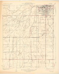
1932 · Gosford
USGS Topo · 1:31,680