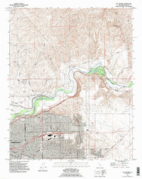
1992 Map of Oil Center
USGS Topo · Published 1995About this map
The Kern River serves as the dividing line between the industrial oil patches of the southern Central Valley and the expanding urban core of Bakersfield. In this early 1990s landscape, the north bank is dominated by a dense network of petroleum infrastructure and small workers' settlements like Oil Center and Oil City. Historical footprints remain visible, such as Gordons Ferry and the Beardsley Weir, which point to the river's essential role in early transport and irrigation.
Find a feature on this map
42 named features on this map. Tap any name to fly to it.
Don’t see what you’re looking for? This feature index may not catch every label — zoom into the map to look around manually.
Map Details
Editions of this 1992 Oil Center Map
This is the sole edition of this map. No revisions or reprints were ever made.
Other maps of this area

1906 · Bakersfield
USGS Topo · 1:62,500

1910 · Buena Vista Lake
USGS Topo · 1:125,000

1912 · Buena Vista Lake
USGS Topo · 1:125,000

1914 · Caliente
USGS Topo · 1:125,000

1929 · Fairfax School
USGS Topo · 1:31,680

1930 · Oildale
USGS Topo · 1:31,680

1931 · Edison
USGS Topo · 1:31,680

1932 · North of Oildale
USGS Topo · 1:31,680

1932 · Fairfax School
USGS Topo · 1:31,680
1932 · Gosford
USGS Topo · 1:31,680