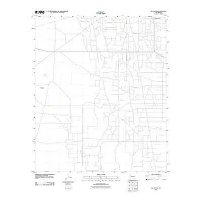
2010 Map of Oil Center
USGS Topo · Published 2010About this map
The settlement of Oil Center stands as the primary hub of activity in this corner of Lea County, where the industrial landscape is dominated by the sprawling infrastructure of the San Simon Oil Field. The grid of service roads, including County Rd-21 and County Rd-28, reveals a high density of development associated with petroleum extraction, cutting across the arid terrain of the Llano Estacado. A notable geographic break in this man-made network is the presence of Dry Lake, a seasonal basin located west of the main oil field. The map illustrates a specialized landscape where the natural topography has been largely reorganized to support the energy economy of southeastern New Mexico.
Find a feature on this map
8 named features on this map. Tap any name to fly to it.
Don’t see what you’re looking for? This feature index may not catch every label — zoom into the map to look around manually.
Map Details
Editions of this 2010 Oil Center Map
This is the sole edition of this map. No revisions or reprints were ever made.
Other maps of this area

1954 · Hobbs
USGS Topo · 1:250,000

1958 · Hobbs
USGS Topo · 1:250,000

1963 · Oil Center
USGS Topo · 1:62,500

1963 · Monument
USGS Topo · 1:62,500

1969 · Hobbs SW
USGS Topo · 1:24,000

1969 · Eunice
USGS Topo · 1:24,000

1969 · Rattlesnake Canyon
USGS Topo · 1:24,000

1978 · Jal
USGS Topo · 1:100,000

1984 · Oil Center
USGS Topo · 1:24,000
1984 · San Simon Sink
USGS Topo · 1:24,000