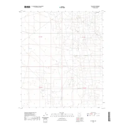
2023 Map of Oil Center
USGS Topo · Published 2023About this map
Oil Center anchors this portion of the Permian Basin, where the grid-like road network and industrial infrastructure reflect decades of energy production in Lea County. The landscape is defined by its arid hydrology, featuring catchment and storage points such as Urssey Tank and the Rock Lake Reservoir, alongside the ephemeral basin of Dry Lake. Topographic variation is subtle, marked primarily by Coyote Hill and the surrounding high plains.
Find a feature on this map
16 named features on this map. Tap any name to fly to it.
Don’t see what you’re looking for? This feature index may not catch every label — zoom into the map to look around manually.
Map Details
Editions of this 2023 Oil Center Map
This is the sole edition of this map. No revisions or reprints were ever made.
Other maps of this area

1954 · Hobbs
USGS Topo · 1:250,000

1958 · Hobbs
USGS Topo · 1:250,000

1963 · Oil Center
USGS Topo · 1:62,500

1963 · Monument
USGS Topo · 1:62,500

1969 · Hobbs SW
USGS Topo · 1:24,000

1969 · Eunice
USGS Topo · 1:24,000

1969 · Rattlesnake Canyon
USGS Topo · 1:24,000

1978 · Jal
USGS Topo · 1:100,000

1984 · Oil Center
USGS Topo · 1:24,000
1984 · San Simon Sink
USGS Topo · 1:24,000