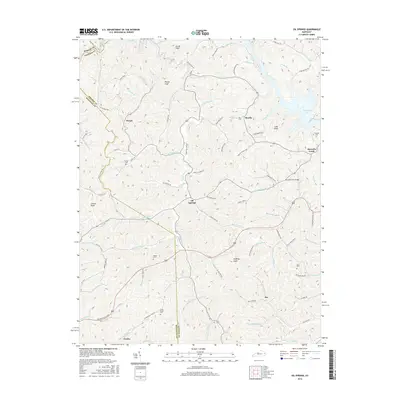
2016 Map of Oil Springs
USGS Topo · Published 2016About this map
Oil Springs lies at the heart of this Appalachian landscape, where the headwaters of numerous creeks carve through the ridges of Johnson and Magoffin counties. The settlement pattern here is dictated by the narrow valleys, with homes and roads like State Road Fork and Jack Caudill Br Rd following the winding paths of Barnetts Creek and Little Paint Creek. To the northeast, the terrain gives way to the waters of Paintsville Lake, while prominent heights such as Potato Knob and Stuffley Knob define the horizon.
Find a feature on this map
102 named features on this map. Tap any name to fly to it.
Don’t see what you’re looking for? This feature index may not catch every label — zoom into the map to look around manually.
Map Details
Editions of this 2016 Oil Springs Map
This is the sole edition of this map. No revisions or reprints were ever made.
Other maps of this area

1886 · Prestonsburg
USGS Topo · 1:125,000

1889 · Salyersville
USGS Topo · 1:125,000

1891 · Salyersville
USGS Topo · 1:125,000

1892 · Prestonsburg
USGS Topo · 1:125,000

1899 · Salyersville
USGS Topo · 1:125,000

1915 · Paintsville
USGS Topo · 1:48,000

1915 · Prestonsburg
USGS Topo · 1:62,500

1917 · Paintsville
USGS Topo · 1:62,500

1918 · Prestonsburg
USGS Topo · 1:62,500
1951 · Dingus
USGS Topo · 1:24,000