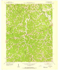
1954 Map of Oil Springs
USGS Topo · Published 1955About this map
Oil Springs serves as the central hub of this mid-century topographic record, situated in a landscape defined by an extensive network of creeks and the active extraction of natural resources. The industrial character of the region is evident through the numerous Oil Wells and Gas Wells scattered throughout the drainage basins of Paint Creek and Little Mine Fork. This era shows a community structured around small valley settlements and local education, with schools like Little Paint Sch and Painters Lick Sch serving the rural population. The terrain is marked by significant elevations such as Cotton Knob and Stuffley Knob, which are connected by a winding State Road. For genealogists and local historians, the map provides a precise look at the placement of family names on the landscape before modern development altered these traditional eastern Kentucky communities.
Find a feature on this map
67 named features on this map. Tap any name to fly to it.
Don’t see what you’re looking for? This feature index may not catch every label — zoom into the map to look around manually.
Map Details
Editions of this 1954 Oil Springs Map
This is the sole edition of this map. No revisions or reprints were ever made.
Other maps of this area

1886 · Prestonsburg
USGS Topo · 1:125,000

1889 · Salyersville
USGS Topo · 1:125,000

1891 · Salyersville
USGS Topo · 1:125,000

1892 · Prestonsburg
USGS Topo · 1:125,000

1899 · Salyersville
USGS Topo · 1:125,000

1915 · Paintsville
USGS Topo · 1:48,000

1915 · Prestonsburg
USGS Topo · 1:62,500

1917 · Paintsville
USGS Topo · 1:62,500

1918 · Prestonsburg
USGS Topo · 1:62,500
1951 · Dingus
USGS Topo · 1:24,000