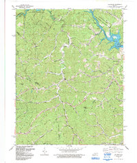
1992 Map of Oil Springs
USGS Topo · Published 1992About this map
The rugged drainage basins of Little Paint Creek and Greasy Creek define this portion of the Cumberland Plateau in Eastern Kentucky, where the topography is heavily marked by small-scale resource extraction. By the early 1990s, dozens of Gas Wells were established along the deep hollows and ridgelines, particularly concentrated near Oil Springs and Manila. The northern reaches are dominated by the Paintsville Lake State Wildlife Management Area, which surrounds the sprawling fingers of Paintsville Lake and its many tributaries like Fish Trap Creek and Barnetta Creek.
Find a feature on this map
45 named features on this map. Tap any name to fly to it.
Don’t see what you’re looking for? This feature index may not catch every label — zoom into the map to look around manually.
Map Details
Editions of this 1992 Oil Springs Map
This is the sole edition of this map. No revisions or reprints were ever made.
Other maps of this area

1886 · Prestonsburg
USGS Topo · 1:125,000

1889 · Salyersville
USGS Topo · 1:125,000

1891 · Salyersville
USGS Topo · 1:125,000

1892 · Prestonsburg
USGS Topo · 1:125,000

1899 · Salyersville
USGS Topo · 1:125,000

1915 · Paintsville
USGS Topo · 1:48,000

1915 · Prestonsburg
USGS Topo · 1:62,500

1917 · Paintsville
USGS Topo · 1:62,500

1918 · Prestonsburg
USGS Topo · 1:62,500
1951 · Dingus
USGS Topo · 1:24,000