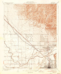
1935 Map of Oildale
USGS Topo · Published 1935About this map
The Kern River and an extensive network of irrigation works define the landscape north of Bakersfield during the mid-1930s. This survey, compiled from data gathered in 1929 and 1930, illustrates the transition from the irrigated agricultural plains along Rosedale Avenue to the burgeoning oil-related infrastructure of Oildale. The industrial character of the era is evidenced by the massive Transmission Line and the concentration of storage tanks and facilities near Oil Junction and Seguro. Rural life is anchored by local institutions such as Norris Sch, Standard Sch, and Beardsley Sch, which served the families working the surrounding fields and oil operations. The Kern County Landing Field appears at a vital juncture, situated between the Southern Pacific tracks and the Golden State Highway, highlighting the convergence of rail, road, and early aviation transport in the San Joaquin Valley.
Find a feature on this map
23 named features on this map. Tap any name to fly to it.
Don’t see what you’re looking for? This feature index may not catch every label — zoom into the map to look around manually.
Map Details
Editions of this 1935 Oildale Map
3 editions found
Other maps of this area

1906 · Bakersfield
USGS Topo · 1:62,500

1910 · Buena Vista Lake
USGS Topo · 1:125,000

1912 · Buena Vista Lake
USGS Topo · 1:125,000

1914 · Caliente
USGS Topo · 1:125,000

1929 · Stevens
USGS Topo · 1:31,680

1929 · Fairfax School
USGS Topo · 1:31,680

1930 · Famoso
USGS Topo · 1:31,680

1930 · Rosedale
USGS Topo · 1:31,680

1930 · Oildale
USGS Topo · 1:31,680

1932 · North of Oildale
USGS Topo · 1:31,680