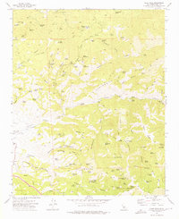
1972 Map of Oiler Peak
USGS Topo · Published 1975About this map
Oiler Peak stands as the high point in this landscape of steep canyons and scattered springs along the Kern and California borderlands. The topography is defined by the winding course of Caliente Creek, which carves through the terrain past distinctive locations like the Devils Elbow and a historic Fig Orchard. This 1970s survey reveals a working landscape where transportation and resource extraction intersect, evidenced by the Southern Pacific railroad line skirting the southern boundary and the Aunt Rosa Mines tucked into the eastern ridges.
Find a feature on this map
96 named features on this map. Tap any name to fly to it.
Don’t see what you’re looking for? This feature index may not catch every label — zoom into the map to look around manually.
Map Details
Editions of this 1972 Oiler Peak Map
3 editions found
Other maps of this area

1914 · Caliente
USGS Topo · 1:125,000

1915 · Mojave
USGS Topo · 1:125,000

1929 · Bena
USGS Topo · 1:31,680

1930 · Bear Mountain
USGS Topo · 1:31,680

1932 · Bena
USGS Topo · 1:31,680

1933 · Bear Mountain
USGS Topo · 1:31,680

1943 · Tehachapi
USGS Topo · 1:62,500

1943 · Emerald Mtn
USGS Topo · 1:62,500

1943 · Cummings Mountain
USGS Topo · 1:62,500

1943 · Breckenridge Mountain
USGS Topo · 1:62,500