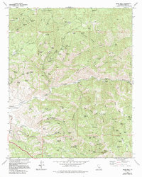
1972 Map of Oiler Peak
USGS Topo · Published 1994About this map
Caliente and the nearby stop at Bealville serve as central points in this terrain defined by steep canyons and historical transit routes in Kern County. The map documents an era when the landscape was heavily influenced by ranching and regional transit, evidenced by features like the Caliente Teamster Cutoff and the winding Tollhouse Grade. These routes connected the lower basins to the high points of the Tehachapi Mountains, including Oiler Peak and the surrounding Centennial ridge. Water sources are meticulously noted, from the Gaging Station on Caliente Creek to numerous named springs such as Aunt Rosa Mines Spr and Poison Oak Spring, highlighting the critical importance of water management in this arid environment. The presence of a Fig Orchard and various cattle-related landmarks like Fence Camp Flat suggests a landscape dedicated to agriculture and livestock before modern suburban expansion reached these slopes.
Find a feature on this map
105 named features on this map. Tap any name to fly to it.
Don’t see what you’re looking for? This feature index may not catch every label — zoom into the map to look around manually.
Map Details
Editions of this 1972 Oiler Peak Map
3 editions found
Other maps of this area

1914 · Caliente
USGS Topo · 1:125,000

1915 · Mojave
USGS Topo · 1:125,000

1929 · Bena
USGS Topo · 1:31,680

1930 · Bear Mountain
USGS Topo · 1:31,680

1932 · Bena
USGS Topo · 1:31,680

1933 · Bear Mountain
USGS Topo · 1:31,680

1943 · Tehachapi
USGS Topo · 1:62,500

1943 · Emerald Mtn
USGS Topo · 1:62,500

1943 · Cummings Mountain
USGS Topo · 1:62,500

1943 · Breckenridge Mountain
USGS Topo · 1:62,500