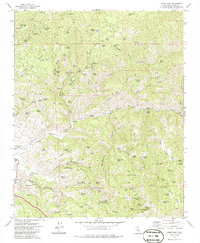
1972 Map of Oiler Peak
USGS Topo · Published 1986About this map
Oiler Peak rises above a landscape defined by deep drainage systems and early mountain transport routes in the southern Sierras. The settlement at Bealville marks the path of the Southern Pacific railroad as it winds through the foothills, providing a vital link for the regional transport of goods and people. This era shows the convergence of industrial mining at the Aunt Rosa Mines and the historic cattle-driving routes suggested by the Tollhouse Road and Teamster Cutoff.
Find a feature on this map
102 named features on this map. Tap any name to fly to it.
Don’t see what you’re looking for? This feature index may not catch every label — zoom into the map to look around manually.
Map Details
Editions of this 1972 Oiler Peak Map
3 editions found
Other maps of this area

1914 · Caliente
USGS Topo · 1:125,000

1915 · Mojave
USGS Topo · 1:125,000

1929 · Bena
USGS Topo · 1:31,680

1930 · Bear Mountain
USGS Topo · 1:31,680

1932 · Bena
USGS Topo · 1:31,680

1933 · Bear Mountain
USGS Topo · 1:31,680

1943 · Tehachapi
USGS Topo · 1:62,500

1943 · Emerald Mtn
USGS Topo · 1:62,500

1943 · Cummings Mountain
USGS Topo · 1:62,500

1943 · Breckenridge Mountain
USGS Topo · 1:62,500