
1980 Map of Okanogan
USGS Topo · Published 1980About this map
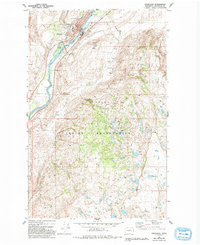
Okanogan sits at the confluence of river commerce and rail transport, bounded by the Colville Indian Reservation to the south. This era shows a community well-established with civic infrastructure, featuring a Museum, an Armory, and Grainger Sch. The Burlington Northern railroad corridor tracks the west bank of the Okanogan River, supporting local industrial activity such as the various Gravel Pits found nearby.
Find a feature on this map
35 named features on this map. Tap any name to fly to it.
Don’t see what you’re looking for? This feature index may not catch every label — zoom into the map to look around manually.
Map Details
Editions of this 1980 Okanogan Map
2 editions found
Other maps of this area

1905 · Okanogan
USGS Topo · 1:125,000

1950 · Boot Mtn
USGS Topo · 1:62,500

1953 · Omak Lake
USGS Topo · 1:62,500

1954 · Okanogan
USGS Topo · 1:250,000

1957 · Okanogan
USGS Topo · 1:62,500

1957 · Bridgeport
USGS Topo · 1:62,500

1958 · Okanogan
USGS Topo · 1:250,000
1980 · Omak
USGS Topo · 1:24,000
1980 · Joe Lake
USGS Topo · 1:24,000
1980 · White Lakes
USGS Topo · 1:24,000