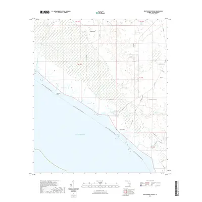
2021 Map of Okefenokee Slough
USGS Topo · Published 2021About this map
The Gulf of Mexico coastline in Taylor County defines this landscape, where the intricate network of the Okefenokee Slough meets the salt marshes and tidal creeks of the Florida Panhandle. This modern survey illustrates a low-lying environment of grassy plains and seasonal wetlands, notably at Eagle Prairie and along the winding courses of Turkey Roost Slough and Big Spring Creek. The small coastal settlement at Bonita Beach serves as a focal point for local access, connected by a grid of rural roads such as Boneta Beach Rd and Co Rd 580.
Find a feature on this map
49 named features on this map. Tap any name to fly to it.
Don’t see what you’re looking for? This feature index may not catch every label — zoom into the map to look around manually.
Map Details
Editions of this 2021 Okefenokee Slough Map
This is the sole edition of this map. No revisions or reprints were ever made.
Other maps of this area

1954 · Warrior Swamp
USGS Topo · 1:24,000

1954 · Hampton Springs
USGS Topo · 1:24,000

1954 · Keaton Beach
USGS Topo · 1:24,000

1954 · Okefenokee Slough
USGS Topo · 1:24,000

1954 · Gainesville
USGS Topo · 1:250,000

1954 · Valdosta
USGS Topo · 1:250,000

1955 · Perry
USGS Topo · 1:24,000

1955 · Rock Islands
USGS Topo · 1:24,000

1955 · Manlin Hammock
USGS Topo · 1:24,000
1956 · Hampton Springs
USGS Topo · 1:25,000