
1963 Map of Oklahoma Lane
USGS Topo · Published 1965About this map
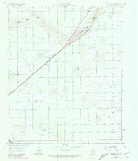
Agricultural irrigation dominates this corner of Parmer Co. during the early 1960s, evidenced by the dense concentration of wells scattered across the High Plains landscape. The small settlement of Oklahoma Lane stands as the primary hub of the area, situated at a junction of local roads. Two major intermittent watercourses, Running Water Draw and Progress Draw, carve shallow paths through the flat terrain, providing natural drainage for the surrounding farmland.
Find a feature on this map
6 named features on this map. Tap any name to fly to it.
Don’t see what you’re looking for? This feature index may not catch every label — zoom into the map to look around manually.
Map Details
Editions of this 1963 Oklahoma Lane Map
2 editions found
Other maps of this area

1954 · Clovis
USGS Topo · 1:250,000

1957 · Clovis
USGS Topo · 1:62,500

1957 · Pleasant Hill
USGS Topo · 1:62,500

1958 · Clovis
USGS Topo · 1:250,000

1963 · Lariat
USGS Topo · 1:24,000

1963 · Lariat NE
USGS Topo · 1:24,000

1963 · Progress
USGS Topo · 1:24,000

1965 · Bovina
USGS Topo · 1:24,000

1965 · Parmerton
USGS Topo · 1:24,000

1985 · Pleasure Lake
USGS Topo · 1:24,000