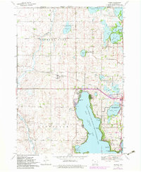
1970 Map of Okoboji
USGS Topo · Published 1983About this map
West Okoboji Lake and its surrounding glacial landscape define this portion of Dickinson County, where a complex network of conservation areas and lakeside communities took shape by the early 1980s. The map illustrates a high concentration of recreational and ecological sites, from Cayler Prairie in the west to the numerous state game management areas like Hottes Lake State Game Management Area and Marble Lake State Game Management Area to the north.
Find a feature on this map
56 named features on this map. Tap any name to fly to it.
Don’t see what you’re looking for? This feature index may not catch every label — zoom into the map to look around manually.
Map Details
Editions of this 1970 Okoboji Map
2 editions found
Other maps of this area

1954 · Fairmont
USGS Topo · 1:250,000

1958 · Fairmont
USGS Topo · 1:250,000

1960 · Sioux Valley
USGS Topo · 1:24,000

1970 · Milford
USGS Topo · 1:24,000

1970 · Lakefield SW
USGS Topo · 1:24,000

1970 · Okoboji
USGS Topo · 1:24,000

1970 · Lakefield SE
USGS Topo · 1:24,000

1970 · Spirit Lake SE
USGS Topo · 1:24,000

1970 · Lake Park SE
USGS Topo · 1:24,000

1970 · Spirit Lake
USGS Topo · 1:24,000