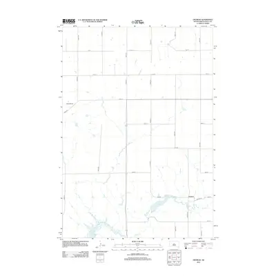
2012 Map of Okobojo
USGS Topo · Published 2012About this map
Sully Buttes rise above the high plains of Sully County in this 2012 study, overlooking a landscape defined by the drainage of Okobojo Cr and the vast waters of Lake Oahe at the southwestern edge. The map captures the quiet rural character of the Okobojo settlement, which sits adjacent to Lake Okobojo and the winding course of Okobojo Cr. The local geography is governed by a strict section-line road grid, featuring numbered avenues and streets like Okobojo Ave and 183rd St, which facilitate access to the agricultural hinterlands. This survey illustrates the relationship between the prairie terrain and the engineered water systems of the Missouri River basin, shown through the intricate shoreline of the reservoir and the residential clustering at Finderosa Pl.
Find a feature on this map
24 named features on this map. Tap any name to fly to it.
Don’t see what you’re looking for? This feature index may not catch every label — zoom into the map to look around manually.
Map Details
Editions of this 2012 Okobojo Map
This is the sole edition of this map. No revisions or reprints were ever made.
Other maps of this area

1954 · Pierre
USGS Topo · 1:250,000

1958 · Pierre
USGS Topo · 1:250,000

1965 · Artichoke Butte
USGS Topo · 1:24,000

1965 · Okobojo NE
USGS Topo · 1:24,000

1965 · Artichoke Butte SW
USGS Topo · 1:24,000

1965 · Okobojo
USGS Topo · 1:24,000
1967 · Okobojo SE
USGS Topo · 1:24,000

1969 · No Heart Creek SE
USGS Topo · 1:24,000
1973 · Iron Post Buttes SE
USGS Topo · 1:24,000
1973 · Okobojo SW
USGS Topo · 1:24,000