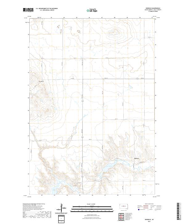
2021 Map of Okobojo
USGS Topo · Published 2021About this map
Sully Buttes rise above the Missouri River drainage in this high-plains landscape, where the agricultural grid meets the waters of the Lake Oahe reservoir. The small settlement of Okobojo sits near the confluence of Okobojo Creek and its namesake Lake Okobojo, reflecting a local geography shaped by both natural drainage and modern water management. This area of Sully County is defined by a strictly surveyed section line road network, including thoroughfares like Onida Rd and Okobojo Ave, which connect isolated homesteads to the river's edge. The map reveals the transition from the high, dry tablelands down into the intricate coulees and breaks that lead to the expansive shoreline of the reservoir. This detailed view captures the specific intersection of prairie land use and the development of water-focused access roads like Lakeside Dr and Finderosa Pl in the early 21st century.
Find a feature on this map
31 named features on this map. Tap any name to fly to it.
Don’t see what you’re looking for? This feature index may not catch every label — zoom into the map to look around manually.
Map Details
Editions of this 2021 Okobojo Map
This is the sole edition of this map. No revisions or reprints were ever made.
Other maps of this area

1954 · Pierre
USGS Topo · 1:250,000

1958 · Pierre
USGS Topo · 1:250,000

1965 · Artichoke Butte
USGS Topo · 1:24,000

1965 · Okobojo NE
USGS Topo · 1:24,000

1965 · Artichoke Butte SW
USGS Topo · 1:24,000

1965 · Okobojo
USGS Topo · 1:24,000
1967 · Okobojo SE
USGS Topo · 1:24,000

1969 · No Heart Creek SE
USGS Topo · 1:24,000
1973 · Iron Post Buttes SE
USGS Topo · 1:24,000
1973 · Okobojo SW
USGS Topo · 1:24,000