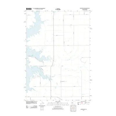
2012 Map of Okobojo SW
USGS Topo · Published 2012About this map
Lake Oahe dominates the western edge of this central South Dakota landscape, where the Missouri River's impoundment creates a complex shoreline of flooded draws and inlets. The terrain is defined by the drainage of several prairie streams, most notably Okobojo Cr in the north and the winding courses of Spring Cr and Cow Cr further south. The land is organized by a strict section-line road grid, including 191st St and 199th St, reflecting the systematic agricultural development of Hughes County. Local access points like Cow Creek Rd and Powerhouse Rd provide connectivity between the high prairie and the recreational and water-management features along the reservoir's edge. This map documents the rural character of the region in the early 21st century, showing a mix of established section roads and modern residential ways such as E Spring Creek Dr.
Find a feature on this map
18 named features on this map. Tap any name to fly to it.
Don’t see what you’re looking for? This feature index may not catch every label — zoom into the map to look around manually.
Map Details
Editions of this 2012 Okobojo SW Map
This is the sole edition of this map. No revisions or reprints were ever made.
Other maps of this area

1924 · Pierre
USGS Topo · 1:62,500

1937 · Oahe
USGS Topo · 1:62,500

1954 · Pierre
USGS Topo · 1:250,000

1958 · Pierre
USGS Topo · 1:250,000

1965 · Okobojo NE
USGS Topo · 1:24,000

1965 · Okobojo
USGS Topo · 1:24,000

1967 · Pierre NE
USGS Topo · 1:24,000
1967 · Okobojo SE
USGS Topo · 1:24,000
1973 · Iron Post Buttes SE
USGS Topo · 1:24,000
1973 · Willow Creek Butte
USGS Topo · 1:24,000