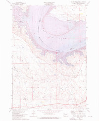
1973 Map of Willow Creek Butte
USGS Topo · Published 1976About this map
Lake Oahe and the winding Missouri River define this landscape along the border of Stanley and Hughes counties. The 1973 survey illustrates a region shaped by the Oahe Dam project, with an indefinite boundary cutting through the center of the waterway. Elevated plateaus and drainages such as Peoria Flats and Giddings Flat overlook the river valley, while the rugged breaks are marked by features like True Draw and Huckfeldt Draw. To the south, the namesake Willow Creek Butte rises as a prominent landmark near a Radio Tower. The map highlights the recreational transition of the riverfront, noting the Oahe Mission Recreation Area and Chantier Creek Recreation Area, providing a detailed look at the Missouri's course before further modern development altered the shoreline access.
Find a feature on this map
15 named features on this map. Tap any name to fly to it.
Don’t see what you’re looking for? This feature index may not catch every label — zoom into the map to look around manually.
Map Details
Editions of this 1973 Willow Creek Butte Map
This is the sole edition of this map. No revisions or reprints were ever made.
Other maps of this area

1924 · Pierre
USGS Topo · 1:62,500

1937 · Oahe
USGS Topo · 1:62,500

1953 · Teton
USGS Topo · 1:24,000

1953 · Oahe SW
USGS Topo · 1:24,000

1953 · Pierre SW
USGS Topo · 1:24,000

1954 · Pierre
USGS Topo · 1:250,000

1958 · Pierre
USGS Topo · 1:250,000
1973 · Iron Post Buttes SE
USGS Topo · 1:24,000

1973 · Iron Post Buttes SW
USGS Topo · 1:24,000
1973 · Okobojo SW
USGS Topo · 1:24,000