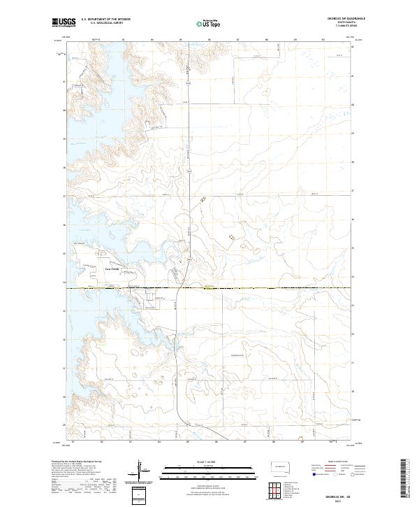
2021 Map of Okobojo SW
USGS Topo · Published 2021About this map
Lake Oahe dominates this landscape on the border of Sully and Hughes counties, where the massive reservoir fills the ancient valley of the Missouri River. The map captures the specialized development along the eastern shoreline, particularly at the settlement of Cow Creek. Here, a network of residential and recreational roads like Walleye Dr, Codgers Cove Rd, and Mallard Pl illustrates the area's modern identity as a destination for water-based activities.
Find a feature on this map
39 named features on this map. Tap any name to fly to it.
Don’t see what you’re looking for? This feature index may not catch every label — zoom into the map to look around manually.
Map Details
Editions of this 2021 Okobojo SW Map
This is the sole edition of this map. No revisions or reprints were ever made.
Other maps of this area

1924 · Pierre
USGS Topo · 1:62,500

1937 · Oahe
USGS Topo · 1:62,500

1954 · Pierre
USGS Topo · 1:250,000

1958 · Pierre
USGS Topo · 1:250,000

1965 · Okobojo NE
USGS Topo · 1:24,000

1965 · Okobojo
USGS Topo · 1:24,000

1967 · Pierre NE
USGS Topo · 1:24,000
1967 · Okobojo SE
USGS Topo · 1:24,000
1973 · Iron Post Buttes SE
USGS Topo · 1:24,000
1973 · Willow Creek Butte
USGS Topo · 1:24,000