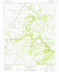
1974 Map of Oktaha
USGS Topo · Published 1978About this map
Oktaha sits along the Missouri-Kansas-Texas railroad line in southern Muskogee County, serving as a focal point for this landscape in the mid-1970s. The map illustrates a region transitioning from the flat prairie lands around Oktaha and Rentiesville into the elevated terrain of the Rattlesnake Mountains to the southeast. A significant historical marker is the Indian Treaty Boundary, which cuts across the central portion of the sheet, reflecting the complex land divisions of Eastern Oklahoma.
Find a feature on this map
28 named features on this map. Tap any name to fly to it.
Don’t see what you’re looking for? This feature index may not catch every label — zoom into the map to look around manually.
Map Details
Editions of this 1974 Oktaha Map
This is the sole edition of this map. No revisions or reprints were ever made.
Other maps of this area

1896 · Okmulgee
USGS Topo · 1:125,000

1900 · Sansbois
USGS Topo · 1:125,000

1900 · Canadian
USGS Topo · 1:125,000

1900 · Okmulgee
USGS Topo · 1:125,000

1901 · Muscogee
USGS Topo · 1:125,000

1905 · Muscogee
USGS Topo · 1:125,000

1909 · Sans Bois
USGS Topo · 1:125,000

1911 · Sansbois
USGS Topo · 1:125,000

1946 · Fort Smith
USGS Topo · 1:250,000

1948 · Keefeton
USGS Topo · 1:62,500